z-coordinate to given (x,y) coordinate?

Deals with generic topics such as logging, framework and so on. If you are not sure where to place your topic just put it here.
Post Reply
User avatar
Bernd Welter
Site Admin
Posts: 2703
Joined: Mon Apr 14, 2014 10:28 am
Contact:

z-coordinate to given (x,y) coordinate?

Post by Bernd Welter »

Hello together,

some months ago I've been asked by a customer whether we can offer a function for the following usecase:
  • The input data is just a valid x,y-coordinate
  • Required output is the z-coordinate aka height above the sea level
Currently we do not provide such a feature within xServers but you can easily access the following API:

http://open.mapquestapi.com/elevation/

Regards from Germany,

Bernd
User avatar
Bernd Welter
Site Admin
Posts: 2703
Joined: Mon Apr 14, 2014 10:28 am
Contact:

Re: z-coordinate to given (x,y) coordinate?

Post by Bernd Welter »

By the way: though we do not return the z-Coordinate as requested in the initial post we are able to provide the elevation profile of a route.
Sample track from Bern (CH) to Bolzano (I)
Bernd Welter
Technical Partner Manager Developer Components
PTV Logistics - Germany

Bernd at... The Forum,LinkedIn, Youtube, StackOverflow
I like the smell of PTV Developer in the morning... :twisted:
jw-alter
Posts: 2
Joined: Tue May 23, 2017 1:50 pm

Re: z-coordinate to given (x,y) coordinate?

Post by jw-alter »

Hi!

Can you tell me how to switch on this height profile?
(To show it on the Map as in your Screenshot)

Thank you!
User avatar
Bernd Welter
Site Admin
Posts: 2703
Joined: Mon Apr 14, 2014 10:28 am
Contact:

Re: z-coordinate to given (x,y) coordinate?

Post by Bernd Welter »

Hello Julian,

Code: Select all

<ns2:ResultListOptions_4 totalRectangle="false" boundingRectanglesOffset="0" boundingRectanglesC="0"
 tollManoeuvres="false" manoeuvreGroups="false" urbanManoeuvres="false" brunnelManoeuvres="false"
 manoeuvreAttributes="false" segmentAttributes="false" segments="true" dynamicInfo="false" 
 detailLevel="STANDARD" polygon="true" binaryPathDesc="false" nodes="true" texts="true" 
 manoeuvres="true" polygonElevations="true"/>
You have to request both polygon and polygonElevations via the ResultListOptions. This will return the Z-coordinate in the polygon then.
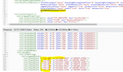
Sample screenshot showing the result list options requesting the z-coordinate in the response.
This also requires the file heights.bin in the maps root folder.

Depending on the framweork you use for the GUI it is then a more or less big challenge to display the diagram.

Best regards,
Bernd
Bernd Welter
Technical Partner Manager Developer Components
PTV Logistics - Germany

Bernd at... The Forum,LinkedIn, Youtube, StackOverflow
I like the smell of PTV Developer in the morning... :twisted:
Post Reply