Hello Julian,
Code: Select all
<ns2:ResultListOptions_4 totalRectangle="false" boundingRectanglesOffset="0" boundingRectanglesC="0"
 tollManoeuvres="false" manoeuvreGroups="false" urbanManoeuvres="false" brunnelManoeuvres="false"
 manoeuvreAttributes="false" segmentAttributes="false" segments="true" dynamicInfo="false"
 detailLevel="STANDARD" polygon="true" binaryPathDesc="false" nodes="true" texts="true"
 manoeuvres="true" polygonElevations="true"/>
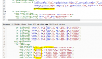
You have to request both
polygon and
polygonElevations via the ResultListOptions. This will return the Z-coordinate in the polygon then.

- Sample screenshot showing the result list options requesting the z-coordinate in the response.
This also requires the file
heights.bin in the maps root folder.
Depending on the framweork you use for the GUI it is then a more or less big challenge to display the diagram.
Best regards,
Bernd