Page 1 of 1
z-coordinate to given (x,y) coordinate?
Posted: Thu Sep 04, 2014 12:11 pm
by Bernd Welter
Hello together,
some months ago I've been asked by a customer whether we can offer a function for the following usecase:
- The input data is just a valid x,y-coordinate
- Required output is the z-coordinate aka height above the sea level
Currently we do not provide such a feature within xServers but you can easily access the following API:
http://open.mapquestapi.com/elevation/
Regards from Germany,
Bernd
Re: z-coordinate to given (x,y) coordinate?
Posted: Thu Jan 12, 2017 8:43 am
by Bernd Welter
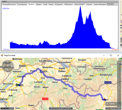
By the way: though we do not return the z-Coordinate as requested in the initial post we are able to provide the elevation profile of a route.

- Sample track from Bern (CH) to Bolzano (I)
Re: z-coordinate to given (x,y) coordinate?
Posted: Thu Dec 07, 2017 1:17 pm
by jw-alter
Hi!
Can you tell me how to switch on this height profile?
(To show it on the Map as in your Screenshot)
Thank you!
Re: z-coordinate to given (x,y) coordinate?
Posted: Fri Dec 08, 2017 9:31 am
by Bernd Welter
Hello Julian,
Code: Select all
<ns2:ResultListOptions_4 totalRectangle="false" boundingRectanglesOffset="0" boundingRectanglesC="0"
 tollManoeuvres="false" manoeuvreGroups="false" urbanManoeuvres="false" brunnelManoeuvres="false"
 manoeuvreAttributes="false" segmentAttributes="false" segments="true" dynamicInfo="false"
 detailLevel="STANDARD" polygon="true" binaryPathDesc="false" nodes="true" texts="true"
 manoeuvres="true" polygonElevations="true"/>
You have to request both
polygon and
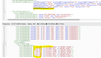
polygonElevations via the ResultListOptions. This will return the Z-coordinate in the polygon then.

- Sample screenshot showing the result list options requesting the z-coordinate in the response.
This also requires the file
heights.bin in the maps root folder.
Depending on the framweork you use for the GUI it is then a more or less big challenge to display the diagram.
Best regards,
Bernd