Page 1 of 1
street category mapping Australia
Posted: Thu Aug 11, 2016 7:28 am
by ulai
We would like to understand the mapping of the street categories in xMAP compared with the street types in Australia. Is there a mapping available?
Re: street category mapping Australia
Posted: Thu Aug 11, 2016 7:33 am
by Bernd Welter
Hello Maik,
could you describe more detailed what the usecase rquirement is?
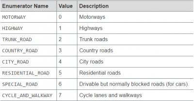
The data structure of the network classes itself is quite simple: just 8 categories.

- http://xserver.ptvgroup.com/fileadmin/files/PTV-COMPONENTS/DeveloperZone/Documents/xServer_public/manual_1.22/Default.htm#API-Documentation/xroute/API_Documentation.html#com.ptvag.xserver.xroute.NetworkClass%3FTocPath%3DDeveloper's%2520Guide%7CAPI%2520Documentation%7CAPI%2520Documentation%2520PTV%2520xRoute%7CComponent%2520xroute%7CEnumerations%7C_____14
Maybeyou are more interested in some additional properties of street segments such as
- Truck Attributes (max weight for bridges, max height for tunnels, closed for combustibles)
- Speed limits
- Is the street solid or not
Best regards Bernd
Re: street category mapping Australia
Posted: Thu Aug 11, 2016 8:42 am
by ulai
Hi Bernd
thks for your input. The requirement is in this unique case indeed as easy as it sounds. in your mapping the highest category is "motorway", while in Australia this would be a "freeway". On a Australian Motorway you can drive less fast. I will try to find a hierarchy of the Australian street categories, but this is the background of the question. By the way, I forgot to mention (not sure whether important), we are using HERE maps.
best regards
mike
Re: street category mapping Australia
Posted: Thu Aug 11, 2016 1:04 pm
by Joost
The classification Bernd mentioned is connected to the road type data from our map provider. This does not take into account any limitation on driving speed like speedlimits, traffic ligths, etc. These limitation are part of a sub classification we call SpeedClass. The speed class however is hidden in most xServers (only xMapmatch can return this speed class).
Visual respresentation of networkclasses arround Sydney:
- Red: NC0 , Motorways , often als called something like ... motorway or M<number>. You find these only around the major cities
- Orange: NC1, Highways, often als called something like ... Highway. These are the major interconnecting roads all over Australia. Keep in mind though that in more rural area the highway can go straight threw a village with a local speed limit without changing the road type.
- Yellow: NC2, trunk road, often they are also called something like ... Highway but usually are a bit smaller then the NC1 highways.
- Green / Brownish: NC3, Country roads , often they are also called something like ... Road. Keep in mind that roads are a more general term also use for lower classes. Used for some major connecting roads in cities and the non-highway connecting roads in rural area's.
Not shown in this example are NC4, major non-connecting city road and NC5 residential road. NC6 and NC7 are usually roads where vehicles are not allowed on.
I hope this helps.
Re: street category mapping Australia
Posted: Thu Aug 11, 2016 1:18 pm
by Bernd Welter
Hello guys,
@Joost: thanks for the attache image!
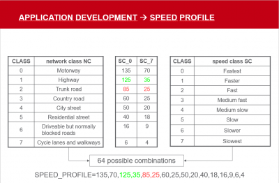
And for Mike: as Joost and I described there are 8 NETWORK classes that are furthermore separated into 8 SPEEDCLASSES from
- incredibly fast
- fast
- bit faster than average
- ..
- bit slowlier than average
- slow
- incredibly slow

- Profile speed values
You can then use those values, e.g. like here:
Code: Select all
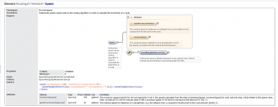
<Speed speedForAirLineDistance="36">
        <SpeedRangeByNetworkClass minimumSpeed="70" maximumSpeed="135" />
        <SpeedRangeByNetworkClass minimumSpeed="35" maximumSpeed="125" />
        <SpeedRangeByNetworkClass minimumSpeed="25" maximumSpeed="85" />
        <SpeedRangeByNetworkClass minimumSpeed="25" maximumSpeed="60" />
        <SpeedRangeByNetworkClass minimumSpeed="20" maximumSpeed="50" />
        <SpeedRangeByNetworkClass minimumSpeed="18" maximumSpeed="40" />
        <SpeedRangeByNetworkClass minimumSpeed="9" maximumSpeed="16" />
        <SpeedRangeByNetworkClass minimumSpeed="4" maximumSpeed="6" />
      </Speed>
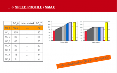
This means 70km/hour on the "incredibly slow" SPEEDCLASS on NETWORK CLASS0 and 135KM/hour on the "incredibly fast" SPEEDCLASS and so on.

- speedclasses within network classes

- Interpolated
Best regards Bernd
Re: street category mapping Australia
Posted: Thu Aug 11, 2016 10:53 pm
by ulai
Hi Joost & Bernd
thks for your inputs. I think we will include freeways into NC0.
rgds -mike